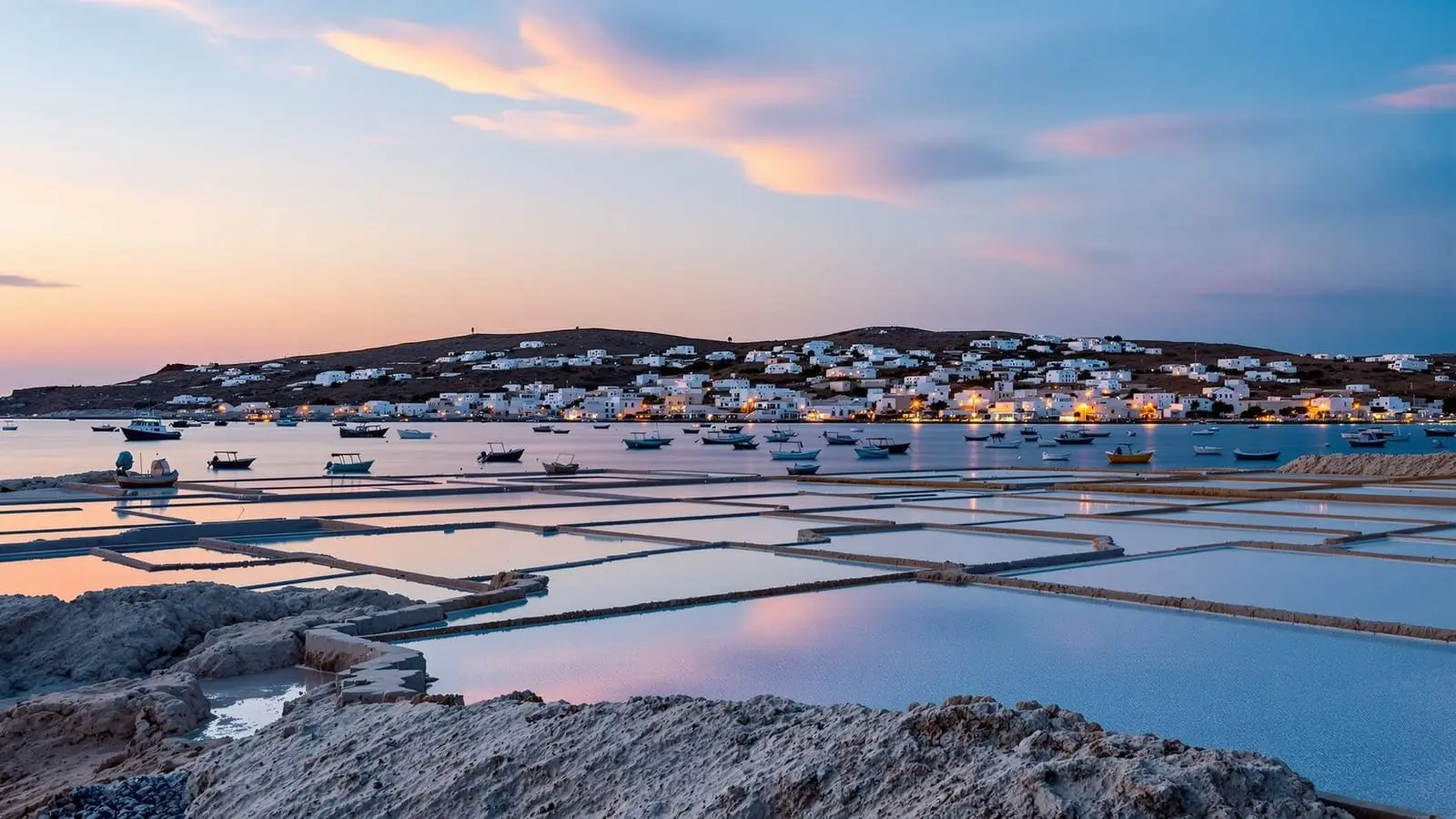
Marsalforn beyond the obvious: corners most visitors miss
Most visitors see Marsalforn's bay front and restaurants, then leave. Here are the salt pans, coastal paths and quiet hours that reward a slower stay.
| What most visitors do | Bay front, a seafood lunch, back on the bus |
| What is worth adding | Qbajjar salt pans, the coast towards Xwejni, the village at the edges of the day |
| Best light | Before 9 am, or after 5 pm in summer |
| Salt pans in use | Roughly April to September |
| Car needed? | Not for the village and the pans; helpful for anything further |
Why Marsalforn gets reduced to a lunch stop
Marsalforn is the part of Gozo that many day-trippers see for an hour. The bus or taxi drops you at the bay front, you walk the promenade, you sit down for fish, you take a photograph of the moored boats, and you leave for the next stop on the circuit (see the top things to do on Gozo). That is a perfectly reasonable way to use a Gozo day, and the Marsalforn destination page says as much: the village is practical rather than dramatic.
The honest point of this article is different. The bay front is the least interesting thing about Marsalforn. What makes the place worth a longer look is what surrounds it: the shallow salt pans cut into the rock, the coastal path that keeps going once the houses stop, the small stretches of shoreline on either side of the village, and the village itself once the day-trip buses have gone. None of it needs a tour, a ticket or much planning. It needs an early start and a bit of patience.
The Qbajjar salt pans, done properly
The Qbajjar salt pans lie about 1 km west of the village along the coastal path. They are shallow troughs carved into the limestone shoreline, and they have been worked for centuries. Sea water is let in, the sun evaporates it, and a white crust is left behind. It is a low-tech process and it still looks like one.
Most people see them as a quick photo stop. A better way is to treat them as a destination in themselves:
- Go at the edges of the day. Before 9 am, or after 5 pm in summer, the low sun gives the pans their shapes and colours. At midday the light is flat and the geometry disappears.
- Match the season to what you want to see. The pans are in use from around April through September, with the salt crust easiest to read in the height of summer. Outside those months the pans are empty, which is quieter but less striking.
- Stay on the paths. This is a working area, not a viewing platform. Do not walk across the pans or take salt home as a souvenir.
- Bring water. There is almost no shade and no kiosk on the way.
If you only have a half-day in the area, the salt pans plus a coffee on the promenade afterwards is a complete and satisfying morning.
Beyond the pans: the coast towards Xwejni
Most visitors turn back at the pans. The coastal path does not. Past Qbajjar the shoreline continues towards Xwejni, and the landscape changes: fewer buildings, more bare rock, the sea very close, and far fewer people than anywhere on the bay front. It is not a signposted trail with cafés at intervals. It is open limestone coast, so it suits people who are comfortable walking without services.
Practical advice, kept deliberately simple:
- Wear proper shoes. The rock is uneven and becomes slippery when wet.
- Take a hat and more water than you think you need. Shade is scarce.
- Walk out as far as feels comfortable, then turn back. There is no prize for the furthest point.
- Check the weather and the sea. On a windy day the exposed coast is much less pleasant, and the spray can reach the path.
For the wider network of routes, see our guide to hiking Gozo’s coastal paths from the Gozo section of the site. If you would rather have a guide handle the route and the navigation, a guided walk through the countryside and cliffs around Ta’ Pinu↗ covers the west of the island, which is a different stretch of coast from the one at Marsalforn but a similar kind of walking.
Swimming: manage your expectations
Marsalforn does not have a proper sandy beach. Swimming happens from rocky platforms at the base of the promenade and from the pier at the east end of the bay. There is a small sandy section that is sometimes usable at low tide, but it is not why anyone should come here.
For sand, Ramla Bay (Ramla Beach on many maps) is about 6 km east of the village, around 10 minutes by car. The sand is red-golden and the water is cleaner, but it is a separate outing and it is the busiest beach on the island in summer. Our advice is to keep the two plans apart: Marsalforn for rocky swimming and walks, Ramla Beach as its own half-day, ideally early or late.
The village at the quiet times
This is the part of Marsalforn that day-trippers never see. In the early morning the promenade belongs to locals, fishermen and a few joggers, and a pastizzi and a coffee at the local bars on the bay front costs you almost nothing and tells you more about the village than the restaurant menus do. Late in the evening, once the dinner crowd has thinned, the bay is calm and the lights on the water are worth five minutes of standing still.
The seasons matter too. In summer Marsalforn is at its liveliest and still relaxed by Malta standards. From April to May the sea is cool and the village is quiet. In September and October the water is still warm and the crowds thin out. From November to March many visitors would call it very quiet: the salt pans are empty, swimming is for the hardy, and some restaurants close, so check before you walk anywhere on a recommendation. If a slow, low-key stay is what you want, the shoulder months are the best compromise.
What the bay front does well
None of this is a reason to skip the restaurants. Il-Kartell, right on the waterfront, is the most consistently recommended place to eat in Marsalforn and it fills up most evenings in season, so book ahead. Oleander in the village centre is a cheaper, more casual option for pasta and pizza. Ta’ Frenc, about 3 km south of the village, is the choice for a special dinner and worth the taxi.
If you want a more structured evening, a wine tasting paired with a dinner cooked in an open kitchen↗ is a good way to taste Gozitan produce without choosing a restaurant, and our Gozo food and cheese guide covers gbejniet and more. Our Gozo evening experiences guide lists what else is open once the day-trippers have left.
How to fit these corners into a Gozo stay
Marsalforn is not a place that needs more than a night or two on its own, but the corners above fill a slow morning very well. A sensible shape for a stay looks like this:
- First morning: walk to the Qbajjar salt pans before 9 am, continue along the coast as far as you like, and return for breakfast on the promenade.
- Midday: swim from the platforms, eat, and rest. This is the hot, flat-light part of the day and the wrong time for the pans.
- Afternoon: use a car, taxi or bus for Victoria and the Citadella, or Xaghra and the temples. From Marsalforn these are short hops: 8 minutes to Victoria and 10 to Xaghra by car.
- Evening: the promenade, dinner, and a last look at the bay.
If you have a third day, a bike is a good way to link the quieter corners. A guided e-bike tour↗ takes the effort out of the hills, and our guide to cycling in Malta and Gozo is worth reading before you hire anything yourself. For the view from the sea, a catamaran day around Gozo and Comino↗ shows you the north coast from the water, though it starts from Malta and is a long day.
On getting around: the Gozo hop-on bus stops at Marsalforn and our Gozo hop-on bus guide explains how it works. The Gozo ferry from Cirkewwa to Mgarr is 4.65 euros return for an adult foot passenger, and seasonal timetables are on gozochannel.com. From Mgarr to Marsalforn is about 25 minutes by car. If you are still choosing a base, read Gozo vs Malta: where to stay and the Gozo-only three-day itinerary to see how Marsalforn sits in a longer plan.
What to skip
Honesty is the point of this site, so here are the things not worth your time:
- The salt pans at midday. They look like grey troughs in flat light. Come back at the edges of the day.
- Marsalforn as a sunbathing beach. It is a rocky-platform swimming spot. If you came for sand, go straight to Ramla Beach.
- The walk to Xlendi. Marsalforn and Xlendi are on opposite sides of the island, and the cliff path that connects them is a serious walk for experienced hikers, not a casual stroll. Take a taxi or drive.
- A packed schedule. The reason these corners work is that nothing is urgent. If you try to tick off the village in an hour, you will see the bay front and miss the rest.
A few honest caveats
The area around the pans and the coast is exposed. In strong wind, in rain, or in the hottest part of a summer day, the walk is less enjoyable and, on wet rock, less safe. There is no formal visitor infrastructure at the pans: no ticket office, no opening hours, no guide on site. If you want history and context rather than a walk, you will get more from a Citadella or temple visit than from standing at the salt pans.
Opening times, ferry timetables and bus routes change, so check gozochannel.com for the ferry, tallinja.com for buses and heritagemalta.mt for the temples before you travel.
Frequently asked questions: Marsalforn’s quieter corners
How long should I give the salt pans? Treat them as a short morning outing rather than a full day. On a day trip, allow about half an hour; if you stay, combine them with a longer coastal walk.
Are the salt pans worth visiting outside summer? They are still a quiet, atmospheric stretch of coast, but the pans are not in use from around October to March, so you will see empty troughs rather than the white crust of the harvest season.
Can I do this without a car? Yes. The village, the salt pans and the coastal path are all reached on foot, and the Gozo hop-on bus stops at Marsalforn. A car or taxi only becomes necessary when you add Dwejra, Xaghra and Victoria on the same day.
Related guides

Best beaches in Malta, Gozo and Comino: sandy vs rocky — the honest guide
80% of Malta's coast is rocky. This guide names every real sandy beach, the best rocky swim spots, and which Instagram beaches are overcrowded traps.

Cycling in Malta and Gozo: what's realistic and what to avoid
Can you cycle in Malta? Honest guide to cycling on Malta's main island, e-bike tours in Gozo, rental options.

The 12 best day trips from Malta (ranked honestly)
The 12 best day trips from Malta honestly ranked: Gozo by ferry, Comino Blue Lagoon, Sicily by catamaran, Mdina, Three Cities, and more.

E-bike tours in Malta and Gozo: what's available and what's worth it
E-bike options in Malta and Gozo: guided Gozo tour (3.5h), self-guided rentals, and which format suits different visit lengths and fitness levels